


Biggest Canada Casino
Biggest Canada Casino This new slot from Mascot Gaming is very...
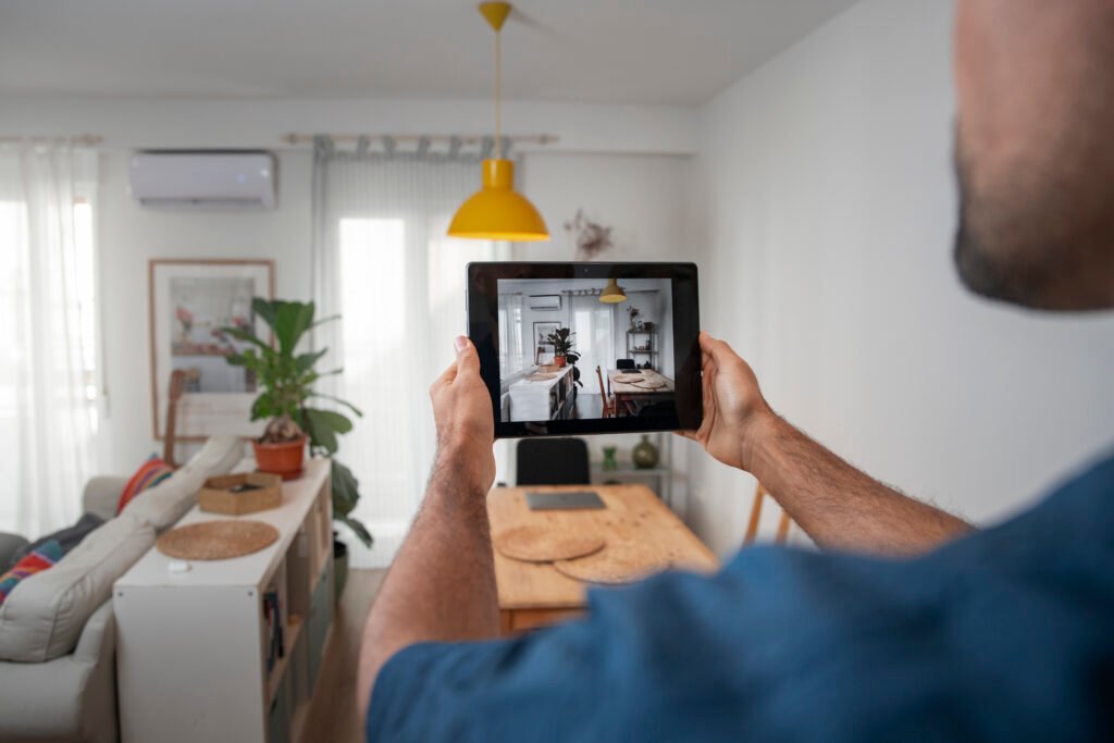

MAP Tech Solutions offers cutting-edge technology solutions to enhance your life. Our division specializes in advanced Automation, Electronic Security, and Networking Solutions for modern homes and businesses.
Our advanced automation solutions allow you to control and monitor your home or business remotely, providing unparalleled convenience and ease of use. Experience the benefits of Affordable Home Automation Systems that are smart, reliable, and tailored to your needs. Enjoy comfort, control, and convenience – all in one place.
Our Home Automation Solutions are designed to optimize performance and reduce energy consumption. With smart devices and seamless networking, you get a fully connected environment where your systems operate efficiently, reliably, and effortlessly.
With state-of-the-art security systems, including CCTV, intruder alarms, and smart door locks, we prioritize your safety by offering vigilant monitoring and immediate alerts to protect your premises with affordable home automation systems.

Experience a customized solution designed for your specific needs through our consultation session

We've designed a customized solution specifically suited to address your distinct requirements

Our expert team will visit your site to horoughly understand your specific requirements and needs

Our proficient team will skillfully install each product, ensuring seamless integration into its designated place
"Super happy with the services! I recently got my home automated with their smart lighting and security systems. The installation was smooth and the team was very professional. Now, I can control my lights and check my cameras from anywhere using my phone. Highly recommend their services to anyone looking to upgrade their home."
Fantastic experience! The team was very knowledgeable and guided me through every step. The smart curtains and video door phone have added so much convenience to my daily life. Plus, the ability to control everything with my voice using Alexa is just amazing. Great job, guys!
Very happy with their service. The digital door locks and smart curtains have made my home so much more secure and convenient. The team was very helpful and provided great support even after the installation. They offer great products at reasonable prices. Highly recommended!
Top-notch service! I wanted to upgrade my home with the latest technology and these guys delivered. From smart video door phones to digital door locks, everything works perfectly. The team was punctual and efficient, and the products are of high quality. I can now manage my home easily even when I am away.
Impressive service! The home automation solutions provided by this company have really upgraded my lifestyle. The smart lighting and security systems are top-notch and very user-friendly. The team was very professional and made sure everything was installed perfectly. Great job!
We aim to revolutionize accessibility, ensuring an effortless experience for all. Our goal is a seamlessly integrated, user-friendly home automation that simplifies management tasks. Enjoy the comforts of your home without complexity – our mission is to enhance living through innovation, making it accessible and enjoyable for everyone.
Upgrade your security system with our advanced CCTV, intruder alarm systems, and video door phone solutions. Keep a vigilant eye, protect your spaces, and communicate seamlessly for serenity and peace of mind.
Revolutionise your entertainment with our home theatre for a cinematic experience. Amplified audio with high-quality stereo system speakers with dynamic sound quality. Our inventive projectors bring reels to life, catering to various applications like movies, games, sports, and professional presentations in your office, delivering an extraordinary audiovisual experience.
Get a seamless and uninterrupted internet with our Wi-Fi networking solution for your premises, in addition to Wi-Fi Extenders, which allow you to access your network from any corner of your home or office with the same password.
Our team of experts is poised to provide tailored consultations,
guiding you towards achieving your specific objectives. We invite you to collaborate with us in crafting a space that goes beyond mere functionality, aiming for something truly extraordinary. Together, we
can design an environment that not only meets your practical needs but also exudes a sense of awe and excellence. Let’s embark on this journey together to create a space that seamlessly aligns with your vision and surpasses your expectations.
MAP Tech Solutions offers cutting-edge technology solutions to enhance your life. Our division specializes in advanced automation, electronic security, and networking solutions tailored for modern homes and businesses. We provide affordable home automation systems and innovative home automation solutions designed to make your spaces smarter, safer, and more efficient.


Slot Machines Laws In Canada They easily could be in the...
A smart home is a house with devices connected to the internet. You can control things like lights, heating, and entertainment systems from your phone or voice commands, making life easier and safer.
Automation can control lights, fans, curtains, AV systems, geysers, and many other home appliances.
Fill out a form on the MAP Tech Solutions website. Their experts will upgrade your home to a smart home in less than 4 hours, without extra wiring or damaging to your walls & interiors.
MAP Tech Solutions offers personalized smart home solutions tailored to your specific needs. We provide the best options to meet all your requirements within your budget, ensuring you get the most value with our affordable home automation systems.
MAP Tech Solutions helps you choose and install smart home devices like smart switches, CCTV cameras, digital door locks, video door phones, and intruder alarms from the best brands.
Our advanced Home Automation Solutions allow you to control and monitor your home or business remotely, providing unparalleled convenience and ease of use.
En nuestro casino en línea, disfruta de atractivas promociones como el bono de bienvenida y cashback, descubre el juego "sweet bonanza" y aprovecha nuestras ofertas continuas.
Experience the thrill of live dealers and immerse yourself in the real-time casino atmosphere at pocketwin casino, where every spin and shuffle brings excitement like never before.
Experience seamless gaming with easy registration, secure transactions, and quick payouts on our casino app bd, where thrills of slots and live dealers are always at your fingerti.
Disfruta de una experiencia de juego inigualable desde cualquier lugar con su dispositivo móvil en topacio casino, donde las tragamonedas y los bonos atractivos te esperan.
Explore a thrilling casino universe with the extensive range of games, from slots to live dealers at Chicken Road, where top providers deliver exhilarating gambling adventures.
Experience thrilling slots and massive jackpots with jeetwin betting, where safety and reliability are at the forefront, ensuring a secure environment for your gaming adventure.
Dive into the world of online gaming with quick registration, instant deposits, and rapid payouts using richard casino no deposit bonus codes for an effortless betting experience.
Experience the thrill of live dealers and immerse yourself in the real-time casino atmosphere with a Pin Up online game, where professional croupiers enhance your playing moments.
Погружайтесь в азартный мир онлайн казино с бонусами до 100% на первый депозит и 1 вин, где вас ждут кэшбэк и непрерывные акции для постоянных игроков!
Discover a plethora of gaming options at cherry casino online, where an extensive range of slots, live dealer experiences, and top-tier providers ensure endless excitement for eve.
MAP Tech Solutions offers cutting-edge technology solutions to enhance your life. Our division specializes in advanced Automation, Electronic Security, and Networking Solutions for modern homes and businesses.
The site was completed on time by the team, and full attention was given by the care members full-time. overall, the solutions provided were very much up-to-mark.